
seeing the past in the future. The revamped Williamsburg Waterfront

We though that as the weather is getting nicer it would be a good time to run in Brooklyn, down the revamped Williamsburg Waterfront. This diverse and popular neighborhood of Brooklyn like most of New York City has had an ever changing landscape and with it, an interesting story that we are excited to share. We will be running south on Kent Street from North 12th Street to South 10th Street.
Often divided along North and South boundaries, each area of Williamsburg possesses unique characteristics, and the development of both the North and South sides of Williamsburg was unified by the area’s relationship with the East River waterfront. Speculative development ventures and competing ferry services characterized early development patterns. As early as 1799, regularly scheduled ferry service moved passengers between Grand Street in New York and South 1st Street in Williamsburg. In 1802, Richard M. Woodhull, a speculative builder, hired Col. Jonathan Williams to survey and lay out a grid for 13 acres of land between present day North 15th Street and Division Street. The newly surveyed land became known as “Williamsburg” in honor of Col. Williams, but as a result of an inconvenient ferry route, Woodhull was bankrupt by 1811 because of his inability to market the newly subdivided land. A competing development known as Yorktown had a more advantageous ferry route to New York City’s business district, and thus attracted more buyers. The Yorktown ferry ran from the base of the newly created Grand Avenue, which grew to be the main commercial thoroughfare in Williamsburg by 1850.
As Manhattan residents gained easy access to the Brooklyn coast via the new ferry connections, they were attracted to the natural landscape. A bluff located on present-day Bedford Avenue became an attractive location where wealthy New York elite like Cornelius Vanderbilt and James Fisk built waterfront mansions. This early settlement pattern coupled with the speculative real estate ventures that sprung up around ferry nodes was later supplanted by rapid industrialization, spurred by the opening of the Erie Canal in 1825.
During the 19th century, Williamsburg’s waterfront shifted from a residential retreat to a commercial port. Between 1830 and 1851, Williamsburg’s population grew from 1,007 to 35,000 residents. During this period many industries began to open in Williamsburg, including many of the nation’s leading industries such as Pfizer Pharmaceuticals, Standard Oil, Domino Sugar and Schaefer Beer. Unlike the neighborhood of Brooklyn Heights, Williamsburg’s waterfront mansions were quickly divided into rooming houses, and tenements were built to house the new workforce that supported the booming industry. By 1900, Williamsburg was home to more than 100,000 residents.
In 1903, the Williamsburg Bridge opened and many Lower East Side immigrants flooded into Brooklyn in an effort to escape the crowded, dirty slums in lower Manhattan. By 1910, the population of Williamsburg had already doubled to 250,000. Yet this trend of uninterrupted industrial and residential growth was not sustained. After World War II, industrial jobs declined, and overcrowded Williamsburg became unpopular. In the latter half of the 20th century, Williamsburg’s industrial and manufacturing economy collapsed, and the neighborhood struggled to maintain its historic prominence. The Brooklyn-Queens expressway sliced through the city in 1955 and divided the neighborhood.

The view from Bushwick Inlet Park Community Center roof
Now let’s take a look at current waterfront area. Beginning in North Williamsburg our first stop is Bushwhick Inlet Park. Bushwick Inlet Park spans north from N. 9th Street to the south bank of Bushwick Inlet just beyond N. 15th Street in Greenpoint between the East River & the inlet west and Kent Avenue & Franklin Street east. The park is in the early stages of development with one parcel out of five activated for public use. Once completed it will include a separated bike path, two athletic fields, performance garden, a dog park and more.
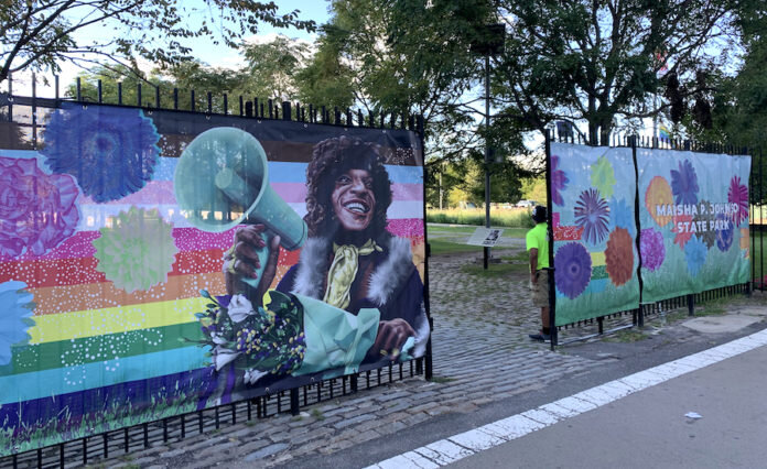
Connecting to Bushwick Inlet Park on its Southern End is the newly named Marsha P. Johnson State Park. Originally known as East River State Park, this 7 acre of waterfront land has been named in honor of Marsha P Johnson, an trans and LGBTQ+ activist, an important figure in the Stonewall uprising and became a fixture in the local community and around the world helping homeless LGBTQ youth throughout the country. Updates are being made to the park to honor Marsha’s legacy but not without controversy. Builders paused the revamp of the park back in March of this year, after family members and Black trans activists slammed the state Parks Department at a community meeting the night before for pushing through an unpopular redesign of the park, and using the late gay rights icon as a publicity prop to promote the $14 million overhaul. They are asking for more public input to ensure that Marsha is honored the right way.
Renderings to the entrance to Marsha P. Johnson Park
As we continued running south along the waterfront we make a quick stop at North 5th Street Pier and Park at the NYC Ferry’s North Williamsburg Stop. The piers were originally built by Manhattan-based firm Douglaston Development as part of a 2006 Greenpoint-Williamsburg rezoning plan that resulted in the construction of a 40-story rental tower at 2 N. Sixth Place. In exchange for the rezoning, Douglaston agreed to transform waterfront property near the development into public parkland, which included the N. Williamsburg ferry stop that opened in 2013, along with the two additional piers and a surrounding park.
Let’s continue south along Kent Street to Grand Street to our next stop, Domino Park. Built on the grounds of the former Domino Sugar Refinery, the park has incredible significance to the growth and development of Williamsburg and the entire Brooklyn waterfront. Dating back to 1856, the Domino Sugar Refinery was once the largest and most productive sugar refinery in the world. At its peak of productivity, it refined 4 million pounds of sugar daily. This site was also central to the growth of the surrounding Williamsburg area, to the industrialization of the Brooklyn waterfront and to the rise of New York City as a global economic powerhouse.

A view of Domino Park looking south with the Williamsburg Bridge in the background
As a result of economic, political and global changes, industrial activity in Brooklyn began to drop off dramatically beginning in the 1950s. Closing its doors in 2004, the Domino Sugar Refinery was the last major active industrial operation on Brooklyn’s once bustling East River waterfront. Following the closure of the Domino Sugar Factory in 2004, this 11-acre site sat dormant as plans for redevelopment were debated by the City, community stakeholders and the development team that purchased the site from Domino. Ultimately, the City approved a residential rezoning in 2010. In 2018, a 6 acre public space officially opened up to the public that includes an elevated walkway, playground, a dog run, a fountain, beach volleyball courts, a fog bridge and open field for activities.
Let’s continue running south under the Williamsburg Bridge to our final stop crossing into the south section of Williamsburg to the South Williamsburg Ferry Pier. There is a small body of water off of the East River known as Wallabout Bay. The name, Wallabout is an English corruption of “de Waal Boght,” meaning the Walloon Bay, after Walloon settlers who immigrated to New Netherlands in the 1630s. This French-speaking Protestant community originated from Belgium, leaving their homeland in search of religious freedom.

A bird’s eye view of Wallabout Bay with the Brooklyn Navy Yard in the foreground
In 1637, Wallabout served as the landing site of first ferry across the East River. The bay was also the site of a notorious floating prison during the Revolutionary War. The Jersey, a British warship docked off Brooklyn during the American Revolution, served as a prison where some 11,500 patriot prisoners of war perished. The nearby Prison Ship Martyrs' Monument in Fort Greene Park houses remains of the prisoners and overlooks the site of their torment and death. The bay eventually became the site of the Brooklyn Navy Yard. Parts of the bay were filled in to expand the yard. In the late 19th century, fill created a small island, as and later fill joined it to the mainland.
This is where will end our tour today. As we look back at where we ran, you can’t help but have appreciation for the way this land has progressed forward without losing a sense of its history. The waterfront is just one of many examples of New York City’s development that helps continue to move the city and country forward.
Williamsburg Waterfront circa 2012 from our Brooklyn Brewery Tour
Thanks for joining us today. We look forward to running with you again soon!